JOURNEY #17 - August 3, 2002
Bonnechere River (Town of Renfrew --> North return)
PICTURES
The Launch Area
A Calm Stretch, Julie In The Distance
Julie Paddling Through A Valley
Keenan & Julie Take A Shore Break
The Two Otters
Heading Back
TRIP REPORT
Have you ever been driving down the highway, and as you are crossing a certain bridge you keep looking down and thinking "That looks like an interesting river, I wonder what it's like?" Such was the inspiration for our journey on the northern stretch of the Bonnechere River, which we had peered down at curiously dozens of times from the heights of Highway 17.
 The Bonnechere begins near McAskill Lake in Algonquin Park and stretches 145km all the way to the Ottawa River at Castleford. It is one of the smaller Ottawa River tributaries. The section we explored on this trip was mostly a deep valley with steep slopes, with shallow waters and occasional deep pools. There were several sets of fast-moving shallows which must surely be a thrill-ride in the spring.
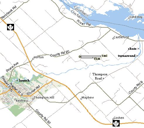
We could find very little information about this section of the river. Only thanks to a response from a request on the ott.rec.canoe-kayak newsgroup could we get a hint about just one place to launch!
We had hoped to find a launch site just south of the chute near Castleford, so we could paddle upstream on the first leg as is our preference. We got off the 17 at County Road 6 and went north to Thompson Road to look for a launch site. What we did find was access to the base of the chute where there were several people fishing, as well as a photographer. It is a beautiful spot, which must be stunning in the spring.
Although it was an interesting discovery, we were no closer to getting on the water, so we decided to follow the lead from the newsgroup and look for the downstream launch at the base of the chute in Renfrew. We took a drive through town and had no luck finding it, so we stopped at the tourist information centre, where they had lots of maps but no idea where a boat could be launched north of the dam. However, with the map of the town they gave us we were able to find Mutual Street and follow it down to the water treatment plant, which was supposed to be the launch site location.
We were greated by a dead end with a fenced in building, and were just about ready to give up, when Keenan decided to take a quick look down a nearby path worn by infrequent tire traffic. It turned out that this was it! The problem was, the track for the left tire was about two feet lower than the right tire, which was not going to work for our vehicle. Julie has spotted a second entrance a few feet back, so we explored that one. Although it was overgrown with trees and there was a deep puddle in the middle, it was the best option, so we tightened the straps on the kayaks and blasted through!
Emerging on the other side we pulled into a weedy area behind the treatment plant where we were presented with a lovely view of flowing waters and tree-lined shores, and a rather steep bank from which we would have to launch. After debating how it is that an Ottawa Sun newspaper box got into the water here, we managed to get moving down the river.
We were barely past the first of many turns and twists when we hit a fast-moving shallows. We were able to pick our way through, and continued on, curious about what lay ahead.
Throughout the entire trip, the banks were never less than 10 feet high, and most of the time much higher (sometimes as much as 100 feet!) but one of the few low spots is along the west bank near the beginning, where there is a farm (and the last piece of cultivated land on this stretch). It was here that we spotted a number of turkey vultures, and then we were surprised by a large hawk which came swooping down the valley and right over our heads! We later spotted two of these magnificent creatures circling high above, screaming "kee-ahhhh" which leads us to believe that they were red-tailed hawks, although we are not certain.
We continued through a more fast-moving shallows, including one that took us several tries to find our way through. Soon we were in sight of the Highway 17 bridge, which towered above us and offered some brief shade in the sweltering sun. Just past the bridge was the most difficult area, a long and wide stretch of fast-moving shallows that we failed to navigate, with each of us running aground several times. It was no trouble to get out and walk the yaks through to deeper waters.
Not too far past this point there were several tiny marshy areas along the banks, where many blue herons were found, some actively hunting frogs.
Julie then spotted something moving in the water. We were thinking muskrat or beaver, but it turned out to be a pair of otters, and we were in for a treat, as they were in a playful mood. They paddled out in front of us and poked their heads way out of the water in unison like synchronized swimmers. Every time Keenan was just about to snap a photo, they would disappear, and emerge in a different location a few seconds later, always just inches apart. This continued for a few minutes before they got bored with us and gave us the slip. We will be smiling about the encounter for some time, and were rather sad about not seeing them on the way back.
The latter portion of this stretch featured many sandbars and pebbled areas along the banks where one could easily stop for a rest or lunch. We were aware of the challenge that we would be facing in returning against the current, so we started to think about picking a spot to stop for lunch and turn around. During our drive along Thompson Road we had spotted a small creek flowing towards the Bonnechere near Lavellee Road, and when we identified it entering the river on the east bank near a nice pebbled flat spot, we beached on some sand and hopped out for a stretch and a quick lunch. We were about 3km from the Castleford chute at this point, having travelled about 12 km.
The 12km return trip required more than a little muscle in several spots. We both walked through the shallows north of the bridge again, and Keenan also got grounded once on the other side of the bridge. During the last km before Renfrew the water was moving pretty quick for our tired muscles and it took some extra effort to make it through. Julie was paddling so hard she knocked her water bottle out of the deck rigging behind her, past Keenan's outstretched hand. We hate to litter, but following it downstream and retrieving it was not an option. Hopefully one of the anglers below the chute will fish it out.
We rounded the final turn and managed to get the yaks up the steep bank and back on top of the van. We blasted back through the puddle and trees (both the van and kayaks came away with several leaves and branches attached) with big smiles on our faces. It had been quite an adventure, and we were certainly rewarded for persevering in our search for a launch site. We stopped of at a local store for some juice and water, and headed for home.
The whole trip took us less than 4 hours. We ended up taking about equal time on both legs, presumably because we spent more time admiring the scenery on the downstream trip. We pretty much paddled flat out all the way back.
We did not see a single human being the entire journey, unless you count the cars passing over the 17 bridge. Beyond the initial stretch near Renfrew, there were actually very few signs of humans at all, one of the few exceptions being the "do not anchor here" warning sign about an underwater pipeline that we encountered somewhere between the bridge and the turnaround point. The water was about a foot deep there, so the huge signs gave us a bit of a laugh.
There is of course good reason why this part of the river seems to be infrequently travelled. The launch site is only accessible to canoes or kayaks, and even then, there doesn't seem to be anywhere downstream where you can take one out, given the steep banks and subsequent lack of trails. If there is somewhere to get out closer to the chute, we could not spot an access road during our travels on Thompson Road.
This would probably be an exhilerating trip in the spring, where the water depth would not be an issue in the fast-moving areas, but the problem would be how to get out of the river! We found the return trip agains the current reasonably challenging in early August, so we imagine it would be next to impossible in the spring.
In any event, if you are not concerned about rubbing the occasional smooth rock with your hull, and you don't mind a bit of work against the current, this is a fantastic afternoon of kayaking. There is always something interesting to look at, and the river is always twisting and turning and changing depths. You might also wish to join the many kingfishers for a little angling. Keenan spotted a number of medium-sized bass in the shallows, and there might be larger fish in the deeper pools.
Just a great day!

