JOURNEY #29 - May 16, 2003
 Charleston Lake: "Islands And Beauty Galore"
PICTURES
Suggested Route, Ottawa To Charleston Lake Provincial Park
Going For A Weekend Or A Week?
Osprey With Nest In Charleston Provincial Park
Start Of Portage From Charleston To Red Horse
Vulture Taking Flight
Turtles On Rock
The Portage To Killenbeck Lake
Unbleached Side Of Bone Found On Island
Turtle In Swamp Between Charleston And Kennebec
Bleached Side Of Bone
Paddling Past Typical Charleston Lake Shoreline
TRIP REPORT
The decision to spend the Victoria Day weekend at Charleston Lake Provincial Park required a camping reservation some months in advance, but nevertheless it all happened in a random fashion. We decided we wanted to drive no more than two hours and go somewhere we hadn't been before. After a quick read about Charleston Lake on the web, the wheels were in motion.
We had a lovely drive down on Friday with a route that went through Merrickville and various small towns including Kitley, which features a charming gas station/grocery on the main drag. We stocked up on ice and gas, and headed for the campsite feeling like the big city was far behind.
The Charleston Lake area is quite fascinating, with an unusual amalgum of northern and southern species, such as flying squirrels (which we did not get a chance to see) and black rat snakes (one of which we saw, some three feet in length). The geology features a complex mix of shield granite, marble, and sandstone.
The lake itself is a haven for loons. It seemed like there were a pair or more in every bay. A full range of birds of prey can be seen gliding over the multitude of islands. The fishing is good, with lake trout in the cold depths and smallmouth bass in the weedy bays. And of course, there's paddling!
Friday evening left just enough time to scout out the launch areas for Saturday. The designated canoe/kayak launch did not strike our fancy at all, as it was nothing more than a small dock extending from a steep rocky bank. The regular boat launch was much more appropriate for kayakers, so that's where we ended up.
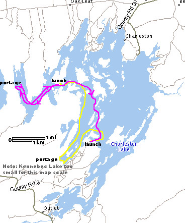
This trip was all about exploring and relaxing, so we had only some loose destinations in mind. This included checking out two portage sites that are part of a loop trip that is described in the Backroad Mapbook.
We started off heading west and then south towards the Killenbeck Lake portage site. The lake is huge (over 150km of shoreline!) so it took a while to adjust to the small scale of our map. Keenan brought his GPS unit for the first time on this trip, but decided to use it only for recording basic statistics rather than for navigation. A big part of the fun was figuring out where we were using the map and finding our way to different places we wanted to explore.
We had a bit of trouble finding the first portage site, but as a result we bumped into a huge turtle sunning on a log. We finally located the portage (it appears that the location is supposed to be signed, but the sign has fallen off) and got out to take a look. The distance was reported as a scant 100m in the Mapbook, but it is easily 600m. However, the trail is very smooth and would have posed few problems. But looking into little Killenbeck Lake, we decided to stick with Charleston.
We headed north along the shoreline that boasts Tallow Rock Bay Trail, passing by some of the interior campsites available in the park. We paused brielf in a small rocky bar to observe a pair of large birds high atop the trees. They turned out to be huge turkey vultures, and as they took flight Keenan snapped a nice photograph.
One of the interior sites is located next to a small bay at the northern tip of the park, and it boasts a truly tranquil setting. As we stopped for a drink a solo loon checked us out, and a pair of vultures glided overhead (they are quite beautiful in flight).
From here we decided to find out way to Donaldson Bay and check out the portage to Red Horse Lake (so-named because of a pictograph of - you guess it - a red horse). We first stopped for lunch at a designated picnic site on a large island. It was warm and sunny, we had paddled a good distance, and the chicken pita sandwiches disappeared quickly. Keenan briefly explored the area and stumbled upon a large bone. If someone can identify its origins for us, that would be appreciated! And if you think the OPP need to know about it, you can tell them the bone is located (within 5 metres) at N 44'32.718 / W 76'02.366.
We headed southwest and then turned north into Donaldson Bay. As with many areas of the lake, there is a shoal right in the middle with several metres of rock just under the water's surface. This shoal is one of just many that was once an above-surface island before the dam was built at Outlet in the 1880s. The result was a 1.3m rise in the water level, resulting in many new shoals that pose a serious danger to powerboaters (anything that makes them slow down to a reasonable speed is a good thing, don't you think?).
We located the well-marked portage and had a bit of a chuckle. The landing looked rather awkward, considering it was angled and rocky. The first ten metres or so looked a bit intimidating as well, as it was jagged, rocky, and uphill. We headed back back along the eastern shoreline of the bay, where Julie learned that the shoal markers are no joke, as she lightly scraped her hull on part of the submerged island.
On the return trip we decided to head out into the middle of the lake towards Democrat Island. In the large bay at the south of the island we came across an enormous grouping of loons, perhaps a full dozen. From there we turned south and cut through the trio of islands just north of the boat launch. As we headed in to Boathouse Cove, it was with some reluctance that we realized our paddling day had come to an end. However, it was definitely time to quit, as the GPS statistics reveal.
In all we travelled 22.5 kilometres. We had been out for 6 hours 55 minutes, of which we were moving for 4 hours 30 minutes at an average spped of 5 km/hr. An hour and twenty-five minutes is a lot of stop time for us, but we ate a full lunch and explored a portage path, which accountes for most of it. Our average speed of 5k includes a loat of coasting while observing wildlife and scenery. The maximum speed recorded was 12.8 km/hr, which is really moving! We don't know when that happened, but we were able to replicate that speed when we tried later, although just barely.
Charleston Lake has a surface area of 2500 hectares, so we know that our 22.5 km trip exposed us to just a small portion of what the lake has to offer. It was an incredible day and we could not have asked for better conditions.

