JOURNEY #27 - May 4, 2003
 Jock River (Richmond >< Munster): "Joy On The Jock"
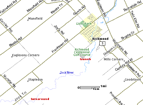
After last week's excursion, we were excited to return to the Jock River and try a new stretch before the water levels drop and a decent trip becomes impossible. Having driven down Joy's Road at the south end of Richmond to the water's edge last time out, we thought we would try it as a launch for a return trip in the direction of the Riverbend golf course. (Aside: Riverbend takes water from the Jock and has applied to take more, which raises obvious concerns given that the river is already reduced to a puddle in some spots during the summer).
It was a perfect day with temperatures approaching 20 celcius, sunshine, and a slight breeze. There was no one else parked on the road when we arrived. It is possible to drive right down to the water but the road was muddy with some deep holes, so we stopped about 30 feet short, unloaded, backed up, and parked off to the side. There's room for a few cars there.
The launch site itself is not a thing of beauty due to the unfortunate dumping of a couple of appliances some years ago, but a few quick paddle strokes south, and you are out of sight of civilization and into a rather sensational stretch of water and wetlands. For the first few minutes the Jock is wide and deep, but after a few twists and turns, that changes dramatically.
The current becomes more obvious, and the navigable part of the river gets narrow and shallow. The bottom is soft, and most of the obstacles are trees, not rocks. The scenery is wonderful. The banks are lined with trees throughout, and wildlife abounds. Beavers are extremely active here, it was rare to see a tree without some gnawing at the base.
The flooded landscape made it a bit of a challenge to locate the main channel at times, but the current always pointed the way. There are several areas where the only passage afforded is a very narrow channel cut off by overhanging trees and logs. One particular spot had a tiny channel, barely twice the width of a kayak, with water shooting through the gap at a good pace. Julie was not able to make it through after several tries, but Keenan was able to brace his kayak on shore just below and give her boat a shove, just enough to get her arms past the logs and trees so she could paddle.
Keenan powered up into the gap and got his paddle in front of one of the trees and pulled himself forward until he too could paddle freely. It was a lot of fun, and there were a few more challenges like that ahead. We encounted several canoeists, but with the exception of one couple, they were all heading downstream, and looked rather confused to see us going in the other direction.
The heavily treed and marshy areas come to an abrupt end somewhere near where Conlry Road would cross if it continued to the river. The banks become farmland, and the bottom turns to rock, smooth in parts, pebbly in others. There were a few dozen sandpiper-type birds in this area, who were quite entertaining in their habits. They would sit still as we approached, and then begin to bob their heads nervously before finally taking off and crying out. We think they were the species known as "Lesser Yellowlegs."
Also in this section we came across a weasel sitting on a log. He was quite a character, and also a bit of a tease. As we paddled by, he seemed to beg our attention by rolling around on his back on the log. We stopped to watch his antics, and just as I readied my camera for a photo, he darted into a hole in the log. When we returned heading downstream, he was still there, and he repeated this exact behaviour. Needless to say, no picture.
We came across a few blue herons but they were extremely shy and were always in flight by the time we could see them.
The current in the section between Green's Road and Munster Road is quite strong, and there is one spot next to an abandoned farm (distinguised by the hand pump on a hill on the north shore) that is particularly challenging, as there is a drop of some significance. We tried several times to paddle through, but keeping the boat straight in necessitated correction with resulted in reduced power and we couldn't manage it. It was simple enough to beach in the dried reeds on the south bank and drag the kayaks to the top. We stopped there and had a quick lunch in the sunshine.
Continuing on, there were several sets of shallow riffles, the only challenge being that there was barely enough water to make a decent paddle stroke against the current. We were just a minute or two short of the Munster Road bridge when we came across some shallow rapids with a rock ledge going clear across, so we decided it was time to head back.
It took us almost three hours on the upstream leg, but only about an hour on the way back, which tells the story of the current. We had some fun shooting through the little chute that had given us so much trouble on the way up. The entire return trip was about 20k, although with the constant twists and turns it's hard to say exactly..
When we returned to Joy's Road, we met up with some locals who verified that neither of the two trips we have enjoyed on the Jock this year will be available within a week or two at most, as the water level will have dropped too far.
Of the two trips, this one was superior due mainly to the fact that you are never in sight of a moving automobile. The beauty of the stretch between Bow of the Jock Park and Richmond is constantly disrupted by nearby traffic. And depending on what you are looking for, the Joy's Road trip is a lot more interesting, since you are constantly twisting and turning and squirting through fast-moving narrows and riffles.
We'll be back to the Jock next April...even earlier in the season if possible!

