JOURNEY #16 - July 27, 2002
Muskrat River (Muskrat Lake/Mud Lake/Muskrat River return)
PICTURES
Cute Coots!
Julie In The Rain
Keenan Behind Beaver Dam
Julie Retrieves Hat During Storm
TRIP REPORT
There is not much to dislike about this trip, although it is a fair drive from Ottawa (about an hour and a half depending on traffic). But at least the directions are easy. Take the 417/17 west past Cobden. About 10 km west of the town you will find Cornerview Road to the right (north). Just follow it to the end as it crosses Fraught Road and heads literally right into the lake. Unload and then park the car on the shoulder. This is a good launch.
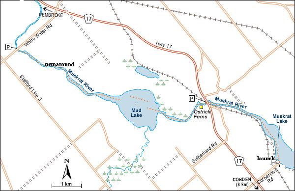 To the east is the majority of Muskrat Lake, which continues about 12km to the public campsite in Cobden. It lies in a preglacial valley that occupies an old fault line. The western shore of this long, narrow lake abuts a clay plain while, to the east, an escarpment of Precambrian rock rises more than 60 metres.
We headed northwest to the Muskrat River. This route follows a section of Samuel de Champlain's 1615 expedition into the interior of Canada. There is a religious camp on the south shore with lots of boats, but as soon as you get to the river you will likely be powerboat free, as the entrance is shallow and weedy. There are few signs of human beings for the rest of the journey, save for a couple of radio towers and a couple of duck blinds.
We immediately encountered two adult loons and a large blue heron, which would be one of perhaps two dozen that we saw on the day. Much of the initial three or four km here features a soft and weedy bottom. In addition to the many herons, kingfishers and barn swallows will also keep you company.
As you approach the 17 bridge (there is a well-used boat launch here which is probably used mostly in early spring, and lots of people fish from shore) the bottom hardens and just past the bridge there is a brief stretch where the immediate shoreline is dense with tall overhanging trees. There are beautiful willows and silver maples. On the north bank just past the bridge there is a peculiar "natural culvert" formed of wood and mud that resembles a little cave. Further along is a very large uprooted tree. There were two men fishing from a canoe in this area who were clearly enjoying the environment and not very concerned about catching fish.
The river turns and south for one kilometre and then resumes its westerly direction again, as you head towards the marshy area known as Mud Lake. The section just before the lake is loaded with wildlife. The most exciting encounter here was with three American Coot adolescent birds who were lined up on a small log. They did not move an inch as we approached, and we had no idea what we were looking at. Keenan drifted in extremely close until he was about 10 feet away between them and the nearest shoreline.
We then became aware that they were quietly crying in what seemed to be a call of distress. Finally they slipped off the log and sloshed their way in a clumsy-looking fashion towards the other bank, where we then spotted the mother, with her black neck and head and white chicken-like bill, thus making the ID of the younger birds possible. They cried in unison with a sound that resembled a whimpering small dog as they headed off down the opposite bank behind their mother. Coots are not a species of duck, although they look like they should be. They have strange movements and splash about awkwardly to intimidate interlopers, which is the reason for their clown-like reputation.
As we entered Mud Lake we were immediately aware of numerous blue herons in the reeds, all of them several hundred feet away from the channel, such as it is. Stick to the right (north) for the best route through the thick vegetation. Julie found the channel while Keenan sloshed about trying to cut through the middle, and eventually disturbing a nesting area for a Black Tern family, who gave him a much deserved talking to, whirling about his head with a somewhat metallic-sounding "kreeeaaa...kikkikkik". Their nest are built on floating vegetation (which we only learned after the trip) which explains why they were rather upset with a kayak making its way through the lillypads. Keenan spotted the chicks about 20 feet from his position and was careful not to further disturb them.
As we emerged back into the river on the other side of the lake, it was about 28 celcius and very humid. We continued down the river into a little stretch where it turns north, just a few minutes from the Water Road (County Road 24) overpass. We stopped to consume copious amounts of water and some cold pizza from a freezer-pack lunch bag before heading back. We saw several more terns but did not see the coots on our way back. We passed a nice older couple in a canoe as we neared the little north-south stretch before the bridge, and out of nowhere came a very localized rainstorm. By the time we were under the bridge and heading east, it was a torrential downpour. Keenan got a chance to try out his new water-resistant camera when Julie's hat blew off and she had to try to retrieve it in the wind and rain and chop.
Soon we were both soaked to the bone, which was a welcome change, as the heat had been rather oppressive by this time. And then the rain was gone. Friends in Ottawa reported that not a drop had fallen there.
There were an abundance of blue herons in the last stretch before the lake, sitting on fallen trees along the shore, shaking themselves dry like dogs. They looked rather funky with their freshly shaken feathers.
When we hit the lake a strong wind was blowing out of the north and slapping the sides of our yaks. We waved to a couple of small children who were running along the shoreline and arrived back at the launch.
We managed this trip in under four hours, but we would have liked to take longer, as we were rather exhausted from the pace. As is often the case, we got started a bit late and had evening committments, so we had to power our way along, particularly on the way back. But we had a great time and would highly recommend this route. If you go from this launch all the way to Water Road and back, that would be about 24 kilometres. If that's too much, you could use two cars and just do the 12 km one-way trip. The river continues all the way to Pembroke, but we don't know if it is possible to continue all the way there or what that section of the river is like.
Note: the map and some of the information here came from Gregory Richardson and the valleyexplore.com website.

