JOURNEY #24 - October 20, 2002
Ottawa River (Shirley's Bay): "A Pleasant Diversion"
The weather was a too nice to pass up. The original plan was to head
to Burnstown and take a little trip up the Madawaska, but we were slow
getting going, and there were several delays on the 417, so we decided
to salvage the afternoon by carefully cutting across three lanes to
Moodie Drive and heading to the launch to the Ottawa River at
Shirley's Bay.
We had been to check out this location earlier in the year, and it was
a zoo of motorized craft, so we put it out of our minds as a place to
paddle. But it was now October 20, and the lot was abandoned with
nothing but a few sailboats in sight on the water.
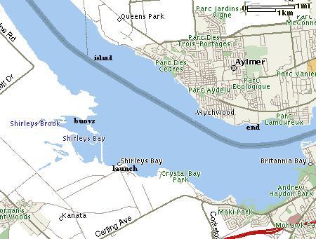
The launch is a huge area of bedrock. Although there are NCC walking
trails in the area, the site actually borders a Department of National
Defence firing range and testing area. We could hear the pop of rifle
shots in the distance. We headed west along the border of the DND
property, as it appeared the most interesting shoreline in the area.
There is a long peninsula that juts out along the western boundary of
Shirley's Bay, and if you follow it along, you come to a marshy
secluded bay that is cut off by DND buoys with warning signs.
Hopefully the picture will turn out on this one, because the warning
markers seem to show why "military intelligence" is sometimes viewed
as an oxymoron.
The markers have a big green circle (of the type that indicates
whatever is in the circle is acceptable...such as a restaurant that
allows smoking or a walking path that allows dogs) featuring - believe
it or not - what appears to be a picture of a bullet inside. As in
"bullets allowed." Why they wouldn't show a red circle with a person
crossed out instead of a "bullets accepted" green circle is one of
those questions that surely only a military spokesperson could answer.
As we moved north adjacent the northernmost point of the DND property
we could see an island over towards the Aylmer side, so we paddled out
into the middle of the Ottawa River (which is known as Lac Deschenes
in this area) in that direction. The wind was of course much stronger,
and there were some decent rolling waves, but it was quite pleasant.
The river is deceptively wide in this area.
We approached the small island which featured a mix of rock and sand
with some deciduous trees in full colour. On the northern side there
was a small solar powered lighthouse with what appeared to be a green
bulb.
As we headed east towards the Aylmer marina, there were many sailboats
in the area, some quite large, They all seemed to pay careful
attention to our location, although at times we felt like racing buoys
as they sailed between us.
We continued along the Aylmer shoreline, which is very shallow. The
water here, as it is for most of the Ottawa, is quite dark, and it can
be difficult to spot the bottom even in two feet of water of less. We
bumped into rocks more than a few times. It was hard to believe how
shallow the water was in some places. We would be paddling along well
out from shore, thinking we were in ten feet of water, only to strike
rock during a paddle stroke.
We came around the large bend here that signals the approach of the
Britannia Bay area and the powerful Deschenes Rapids. This is directly
across from the glass-roofed Nortel building that dominates the
southern shoreline.
The weather had turned for the worse, with the temperature dropping
and the wind picking up and rain obviously on the way, so we took
advantage of two friends who live in the area by beaching at a little
riverside park and imposing on them for hot chocolate and
conversation. After warming up we took a look at the water and the
wind that would be in our faces all the way across, and decided to
accept a ride back to our vehicle.
Arriving back at Shirley's Bay and looking out over the water, it
became apparent that we had paddled much further than expected. The
river is wide here, and the section we paddled from the small island
to the bend was also quite long. It was a surprisingly interesting
paddle and a good workout.
We have to accept that we are now approaching the end of our first
full year of kayaking, but we might make it out again next weekend. We
don't really have the proper equipment for late season trips, and
aren't inclined to buy any at this time, so the number of trips we
have left will probably depend on unseasonably nice weather.
For next spring we definitely have longer trips with some faster water
on our minds, as well as revisiting the ocean. Small rivers rich in
wildlife are still the main attraction, but the thrill of surf
kayaking will likely lure us to at least one trip to one of the coasts
at some point next summer.
