JOURNEY #30 - May 17, 2003
 Singleton Lake/Red Horse Lake: "Failure Turns To Fun"
PICTURES
A Natural Wonder (Twisted Tree)
Close-Up Of Red Horse Pictograph
Pictograph From A Distance
Moving Out Of Singleton Lake Through The Rocky Shallows
A View Of The Portage Landing
TRIP REPORT
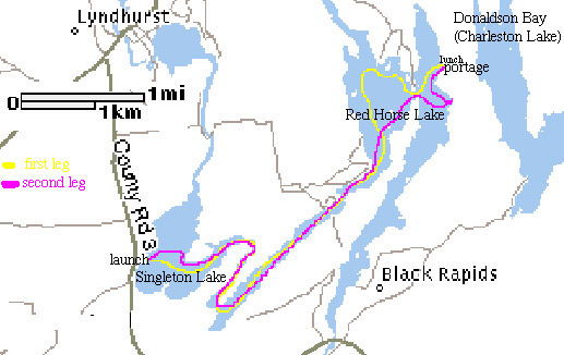
What we had in mind for today was to pick up on the other size of the first portage we had investigated a day earlier. We figured that we could make our way down Black Rapids Road and locate the route from Long Lake into the Gananoque River and north into Red Horse Lake to the other side of the portage from Donaldson Bay.
Well, it didn't work out. We were up and down the road at a turtle's pace at least four times trying to find any sign of a portage route. We even investigated a couple of trails. Finally, we stopped and asked one of the locals, who happened to be a kayaker to boot! He didn't have a clue, and that was our cue to move on to plan b.
Julie took a quick glance at the map and figured we could launch from a trailer park on Singleton Lake, and make our way into Red Horse Lake from there. And it worked out beautifully.
Once we got away from the little community we were into some fun within just a few minutes. We came across two loons and a large heron in the first bay past the point in Singleton Lake, and then became alarmed that perhaps the bend to the east was in fact the end of the lake! However, it was simply a very narrow opening disguised by rock extending into the water. There was a very interesting little current and after a turn south, we were suddenly into a different type of environment.
We couldn't find a name for it on any map, and it is hard to tell where Singleton Lake stops and Red Horse lake begins, but there is a small river or creek that heads south for a km or two, and then takes a sharp turn north for a longer stretch. We spotted a large beaver moving in and out of the rocks and brush along the east shore. Some unidentified birds of prey were circling to the west.
Just when you are starting to wonder if you are on an endless river, you emerge into Red Horse Lake. The northern shoreline is deceptively far away, and we were feeling a few aches by the time we cut east between the points and located the portage landing for the route to Donaldson Bay. The landing here was quite soft, and the little bay was thick with small perch swimming about in large schools.
We stopped for lunch and tried our best not to exhaust our water supply. The sun was out and the UV was high. Keenan briefly explored the portage route, which is hilly but manageable at the start, and appeared fairly comfortable once the initial climb was over.
After lunch we got back at it, and chatted with some people fishing from a small powerboat. There were quite a few small powerboats out on the water, but they were all very focused on fishing. Most were after largemouth and smallmouth bass, although some claimed to be catching "a bit of everything" which likely included northern pike, and possibly some lake trout were taken by those who were trolling. Despite all the anglers, there weren't many cottages and the shorelines were mostly uninhabited.
We headed south in search of the pictograph. We found it at the bottom of a rocky cliff, not too far above water level. It was a bit of an eerie spot. Right at water level there is a small shelf of rock and it causes a slapping sound even when the lake is calm. We took in the atmosphere for a few minutes, and then started our way back.
We took as direct a route as possible, as the heat and yesterday's journey were starting to test us a bit. We stopped before the last bend back into Singleton Lake and Keenan took some photos of a very interesting dead tree. It had taken on a shape that looked anything but dead!
As we headed back to the launch site, two loons played hide and seek with us behind the shoals. We briefly considered paddling up Lyndhurst Creek, but we had friends meeting us back at the campsite, so we called it quits.
This return trip totalled about 17.5 km and we were out for about 3.5 hours. That meant 30km in two days, which we covered in 10.5 hours of combined resting and paddling.
We have since learned that our two journeys covered most of the territory that is part of a 27km trip from Delta to Charleston Lake. If you are interested, it is probably a good full day trip, and you can click here to find out more.
We thoroughly enjoyed our two days on the waters in and around Charleston Lake. The shoreline is never dull, the wildlife is interesting, and there are endless options for kayaking trips.

