JOURNEY #13 - July 13, 2002
South Nation River: "Up Shit Creek"
Our thirteenth trip on the thirteenth day. Very fitting.
Looking at a map of Eastern Ontario, if you look east of Ottawa, there is just one major watershed, which is the South Nation River. We hadn't been able to find out much about it from the usual investigative techniques, but we did get a list of launch sites, and chose a section that would take us close by the Alfred Bog, with the hope of encoutering some interesting wildlife.
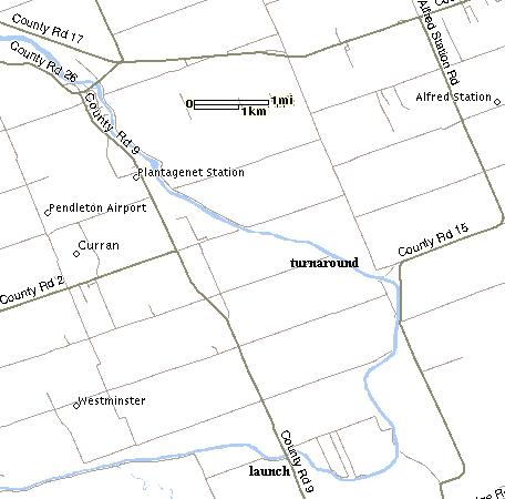
We launched from the Seguin Bridge, which is on County Road 9, about 12 km south of County Rd 17 (known as Highway 17 closer to Ottawa). As usual, the launch was designed for motorboats, with two steel grates for backing a trailer down under the bridge, so we couldn't use it. There was a muddy/weedy area nearby that we were able to use, but it was rather unpleasant, as it was littered with huge dead carp, rotting in the hot sun. It was pretty clear right from the start that these were not going to be the kind of waters where you would want to go for a swim, but a river can change dramatically, so we set out heading northward with the hope of better things to come.
If you launch from here, you actually find yourself heading southeast for about 3 km until you start curving north. For a few minutes we thought we had gone the wrong way after leaving the bridge.
To make a long story short, conditions didn't change much. The river got a little wider as we moved along, but the stench of dead fish (and the actual presence of dead fish) remained. Basically, the South Nation has the appearance of a farm irrigation ditch. There was farmland on both sides for most of the section we covered, and it smelled like it. Even when we hit a stretch that was free from fish carcasses, it still smelled like a toilet.
We did see a few interesting things. Right near the start, we saw an animal crossing the river, and at first thought it was a beaver, then possibly a muskrat...but it was swimming very slowly and did not dive even as we drew near. That's when we figured out it was in fact a gopher! Neither of us had any idea that they were swimmers. The little fellow confirmed his status to us by clambering up the muddy bank and straight into a gopher hole.
As we rounded the bend to head north, a beautiful blue heron flew out from behind a stump and headed east. We have no idea what he was doing there. Perhaps he lost a bet with some of his heron friends, or he simply got lost and was taking a rest. We also saw several varieties of shorebirds and a couple of kingfishers.
Several times we practically bumped right into the huge carp (the live ones) that inhabit the river. The water is so dark that the fish could not see us and we could not see them, until we were right on top of each other. We did run into a couple of locals fishing from shore as well as one group in a motorboat. We asked the two men on shore what they were fishing for, and they mumbled about "whatever we can get" which probably meant "we are just here to drink beer."
We had some fun with domestic animals along the way, including a tiny black cat on a sandy bank in the middle of nowhere that looked just as suprised to see us as we were to see him. We also had some fun with two herds of cows. We are not up to speed on cow science, but the herd of black and white cows was extremely friendly. They stopped what they were doing (nothing much of course) and came right over to the edge to check us out. This contrasted sharply with the herd of brown cows that got up and stormed away from us, bellowing their discontent.
We spotted a large bird of prey flying majestically over the water, which upon closer inspection turned out to be a turkey vulture. Although these birds are not what you might call "attractive" when on land, they are quite beautiful in the air, and in many ways resemble golden eagles in flight. At one point we came upon about a dozen of these creatures hanging out on a large muddy bank. With the vultures staring at us, and the dead carp along the shoreline, it felt a bit like a scene from a doomsday movie.
We don't know exactly where we turned around, but we went past the section where County Road 15 comes alongside, so we figure 10 km would be a good conservative bet. That meant a 20 km trip in about 4 hours, which is some pretty hard paddling, especially on a hot humid day. Julie speculates that we moved fast because we kept hoping for a change around each bend.
Obviously we are not recommending this particular trip or this river to anyone, unless they are studying the impact of farmland runoff on river systems. Nevertheless we had quite a lot of fun, mostly laughing at ourselves, the cows, and the vultures, and we also had an incredible workout.

